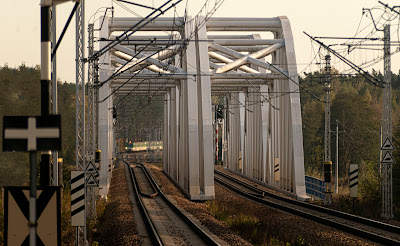
After yesterday's long walk, a somewhat shorter one was in order today. Train assisted. So off I set to the station, to catch whichever train would come first – northbound or southbound. The timetable said it would be the southbound service to Radom, so I decided to take it down to Warka and spend some time down by the river. And so, 45 minutes after leaving home, I'm on the banks of the Pilica river, which demarcates the southern boundary of the Grójec apple-growing district.
Left: looking across the escarpment on the north bank of the Pilica, with the rail bridge in the distance. Photo taken from the steps leading down from the town square to the river.
Below: Sunday siesta time in southern Spain? This is Ulica Lotników in Warka which links the town square to the recently opened Warka Miasto railway station. The neat row of trees and the yellow ochre facade of the single-story house across the road, plus total lack of people in the street give that sleepy-time-down-south vibe.
Below: my train home approaching the Pilica river.
Homeward from the demo
Kielce - the woes of Poland's smaller cities
This time ten years ago:
Wine connoisseurs or wine snobs?
This time 12 years ago:
Poland's golden autumn
This time 13 years ago:
Visceral and permanent - a short story
This time 14 years ago:
Crushed Velvet Dusk in my City of Dreams II


No comments:
Post a Comment