Here's the area around Wałbrzych Szczawienko station, or Nieder Salzbrunn as it was before WW2 (below) The yellow area is where the train is reputedly hiding. The yellow circle highlights the junction from the Waldenburg-Breslau main line from which ran a short spur, leading, in 1936 - nowhere. It ran just 100m or so from the main line before coming to a stop. The main line cuts through a finger of higher ground, rising to a maximum of around 15m before falling away again. This suggests that an artificial hillock was not built over the suspected Gold Train, rather a tunnel would have had to have been excavated between two cuttings. Question is - why. Click to enlarge.
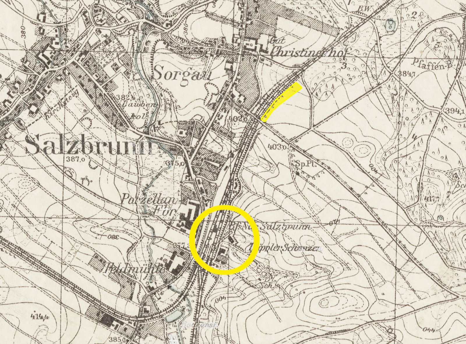
Now here's a composite map with the current Google map of the area superimposed over the 1936 map. Look at the area within the yellow ring above, and compare it with the same area below. I've marked two yellow lines - one which is the 1936 spur, the other being the same spur but on the current map. Different - greater - angle from the main line. Some time after 1936, this spur was extended to run parallel to the main line as far as ul. Uczniowska, before swinging east to what was a communist-era ceramics factory (now the site of a Toyota showroom).

Finally the current Google map on its own. The ceramic line is clearly visible. The tracks have been ripped up, the sleepers remain in place. The question is - was the short spur visible on the 1936 map extended before 1945, or after the war? And most importantly - was a third line built between the main line and the spur? If so - it may well hide the Gold Train.

Any more clues greatly appreciated!
[Update, 31.10.2015 - thanks to Anon for a link to Polish military map prepared in 1956 and published in 1959.] Again, I've marked the positions of the siding and the putative Gold Train site. This suggests that the ceramics factory was built later, and the siding extended to it then. Meanwhile, the 1956/59 map shows an interesting cutting/embankment to the west of Szczawienko station.

This is marked as an eleven-metre drop - enough to hide a train in!
This time last year:
Respect the pedestrian at crossings
[Poland's senate voted this down last week - keep slaughtering pedestrians, o lazy, murderous motorists - the law is still on your side!]
This time two years ago:
Autumnal gorgeousness in Warsaw
This time three years ago:
The genius of Donald Tusk
This time four years ago:
Tragic road accident kills 18: Has Poland learnt anything from it?


10 comments:
Hi Michael,
Thanks for the credit. :) I'll reiterate my thanks to Marek Zielinski for his help with finding these. I found another map (1950 this time) of the same area. Still no factory or spur, although it's harder to see as the map is 1:100 000 this time.
http://www.mapywig.org/m/Czechoslovak_maps/series/100K_Nemecko/Nemecko_100K_103_Liegnitz-Hirschberg_1950.jpg
Same grid ref.
One very dull theory is that the hump of land is simply there to hide the factory from view or act as a blast shield, although ceramics isn't the most dangerous of processes.
Hi Matt,
There's reference to a 1952 1:25,000 US Army map on Marek Zieliński's site, north of Waldenburg - 5163 Freiburg (N.Schl.) Świebodzice. However, it's not available. This series of maps is based on pre-war German maps - maybe indeed even the 1936 one you linked to.
The 'blast shield' theory fits in well with the topography, but is unlikely - more probable is that it's just the higher ground between two cuttings.
I realised the spur's creation date is already answered; jakas1 commented on Part.II of this story that it was built in the 1970s. Link here:
http://jeziorki.blogspot.com/2015/08/gold-rush-part-ii-search-intensifies.html?showComment=1440891465912#c7050099133521883296
Maybe some tree experts could comment on the tree growth on the hump of land; long-term growth, or consistent with recent (<70yrs) planting?
How high is the hump of land? I wonder how easy it would be to cut a section, or sections, through it.
Hello,
Could it contain a trainbunker, like "Anlage Süd"? a safe waitting place to load/unload stuff on the narrow gauge railway that was then leading to the Castle?
At the end of the war covered up with sand, sealed and the railway to the castle dismantled.
Kees
A few thoughts, from archives and a visit:
http://gracefilby.blogspot.co.uk/2015/10/polands-nazi-gold-train.html
ref. dating of old maps mentioned above, they definitely show pre-WW2 landscape. The Czech 100K map from early 1950s is a copy of a German map, pre-1944. Likewise the 25K AMS sheet, and probably even earlier, 1930s, as you say. Neither would have been updated with post-1945 information, for obvious reasons.
This is not to say the maps are useless, it's just that 1950s dating might give someone a false impression they show post-1945 landscape, while they don't.
n.
p.s. http://igrek.amzp.pl/details.php?id=11781322
@ Anonymous - many thanks - very good. Have posted the relevant part of the map to this post.
I've got another post script, added with some hesitation, as it's in Polish only (google translate might help here). Plus, it relates to the "golden train" only indirectly, discussing, in quite some details, potential tunneling elsewhere along this line (locations were actually mentioned in the first press reports back in August this year). That said, the author is both a railway enthusiast, and comes with academic background in railway construction, so it might be an interesting read:
http://tw_kolejofil.republika.pl/tunel.html
http://tw_kolejofil.republika.pl/poc_widma.html
Hi - My father and his family lived very close to there from 1933-1947. Let me know if you have any questions about what was there at that time. Not sure which ceramics factory you believe was built later, but there was one across from the train station area. You'll see it marked as "Porzellan Fbr" (Porcelain Factory).
On a related note is there a chance I could get my hands on that hi res map? I am writing my dad's memoirs and would love to show where he lived with that sort of file.
Post a Comment