Showing posts with label flood. Show all posts

Thursday, 31 October 2024

Valencia and man-made climate change

An unthinkable tragedy for Europe; a year's worth of rainfall in eight hours and over 150 people dead. People who as they woke on Tuesday 29 October 2024 had no idea that this would be their last day on earth, no idea that their lives would be snuffed out by a climate event of unimaginable magnitude. Drowned by surging water or crushed by toppling buildings.

The image that will stay with me of the Valencia floods is not one of people suffering or buildings destroyed, but of this street chock-full of cars (below), swept along by an incredibly powerful surge of water. And I'm thinking – how could this possibly happen? The physics of shifting vehicles – sideways it seems – each weighing one or two tonnes, in such numbers along such a narrow street – the sheer violence of what has happened is all too visible, but hard to take in. But it also shows what a car-dependent species we have become.

Photo credit: B. Hynde-Paywall

There should be no doubts left in anyone's mind that climate change is real; the planet is now over 1.2°C warmer than it was in pre-industrial times, and 0.4°C warmer than in 1980. The effect of that extra heat energy is more powerful storms and heavier rainfalls. Imperial College London's Grantham Institute that studies and attributes the effect of human greenhouse-gas emissions on the climate estimates that the extra 1.2°C of average heat in the system is responsible for rainfall events that can be up to 30% heavier than in pre-industrial times; a deadly difference.

To those who deny the fact that the climate is changing, here's a list of all the major flood events affecting Poland over the last century. Notice the increasing frequency.

Year/eventFatalities in Poland
2024 Central European floods9
2010 Central European floods 25
1997 Central European floods 54
1947 Polish floods  55
1934 flood in Poland 55

Slowly, I feel the message is getting through. Younger people are less likely to want to own or drive a car, and cars make up 12% of human greenhouse gas emissions. But we should all be doing more – or actually, doing less; as I wrote the other day, buying less, travelling less, consuming less.

If we don't, the climate will only continue to deliver more extreme weather events, more frequently. Today it's Valencia; next summer or autumn it could hit you, directly.

This time last year:
On death

This time three years ago:
Improvements on the Radom line

This four years ago:
Rural rights of way, revisited

This time five years ago:

This time six years ago:
Opole in the late-October sunshine

This time seven years ago:
Work begins in earnest on the Karczunkowska viaduct

This time nine years ago:
Sublime autumn day in Jeziorki

This time ten years ago:
CitytoCity, MalltoMall

This time 11 years ago:
(Internet) Radio Days

This time 12 years ago:
Another office move

This time 13 years ago:
Manufacturing a City of Culture

This time 14 years ago:
My thousandth post

This time 15 years ago:
Closure of ul. Poloneza

This time 16 years ago:
Scenes from a suburban petrol station

Wednesday, 11 August 2021

Powerless in Jakubowizna

All summer long, my phones have been buzzing with SMS notifications from the Polish government's security centre (Rządowe Centrum Bezpieczeństwa), warning citizens of impending thunderstorms, downpours, hail, localised flooding, and possible interruptions in electricity supply. The messages warn us to secure any objects outside that might be carried away by strong winds, and tell us to keep watching the weather forecasts.

Online weather charts indeed have been showing the progress of violent storms as they sweep across Poland, typically from south-west to north-east. [I use meteo.pl for its charts that can be localised to the nearest gmina, and its zoomable maps for forecasts, and rainviewer.com for real-time progress of thunderclouds.]

Yesterday evening as I set out of my walk, with one such storm imminent. Though it was still dry, I could see the entire landscape to the west of Chynów illuminated by frequent and massive lightning strikes, incessant rumbles of thunder, and winds whipped up by the downdraft from the water plummeting out of the sky. Soon enough it caught up with me - I had to run home to avoid a soaking. Safe inside my house I watched the spectacular light show; the sun had set at 20:10 but it was far darker than dusk - until the next flash of lightning lit up the garden like day.

Time for supper - kettle on - and the lights went out. And back on again. And off, and on. And then again, until minutes later they finally went out, not to return. My laptop has battery power for several hours; I'm halfway through listening to a Royal Institution science lecture. It continues playing for about ten minutes until the buffered content reaches its end. My phones are working. The torch function is extremely useful - having no candles on the działka, these are the only source of light, apart from the dim glow of the control panel for the security system by the front door, powered by back-up batteries. 

Fortunately, it's summer; in the house it's a comfortable 22.5C. A power-cut in winter would be disastrous, as the działka heating is 100% electric. Darkness, however, means I can't read books, I can't type; outside torrential rain is still pouring down. I run outside to take a look - I can't see any lights in Jakubowizna, nor in Chynów, nor in Nowe Grobice. A fire engine is on its way to an emergency. 

Back indoors, there's no hot water - so can't even take a shower in the dark. It's coming up to nine pm, I decide to wash my teeth and have an early night.

This is the first sustained power cut I've experienced in Poland since the Corpus Christi storm of 2010. That was bad - 36 hours without electricity, and heavy flooding all over Jeziorki.

I am blessed with the ability to fall asleep easily, and so I do, around 21:15. I wake just after midnight to the hum of the refrigerator; opening my eyes, I can see the blinking glow of the internet router on the windowsill. All is well; I go back to sleep, to wake naturally at 06:15. Nine hours of quality rest; some vivid dreams (exploring London Underground tube tunnels in the 1950s with my son, a glass-fronted control centre at the end of a platform, my old office at the CBI, though moved to Warsaw). Maybe going to bed shortly after nine is a good idea? [Maybe time to refresh an idea I had some while back - to go to sleep every day an hour after sunset? In late June, this would be about 10pm, in late December, this would mean going to bed around half past four in the afternoon.]

This morning it's stopped raining. I check the cellar; not too bad - bailing out half a bucket of water from the circular hole in the cellar floor. This needs doing every time it rains heavily, otherwise water osmoses its way up the cellar walls and into the house, leading to damp and mildew. Advice for anyone building a house - don't build a cellar! They are entirely unnecessary in these days of refrigerators, and increased flooding due to climate change means risk of getting waterlogged. A ziemianka - a dug-out cellar built away from the house - is a far better alternative.

Weather likely to be more clement for the next three days - sunshine to dry out the damp soil.

This time last year:
Kilometres of new asphalt

This time two years ago:
One man went to mow

This time four years ago:
My father's penknife and airport security

This time five years ago:
Post-holiday detox diet starts today

This time eight years ago:
Cycle ride up and down the S2 and S79 before they open

This time nine years ago:
Kraks and back in a day by train 

This time ten years ago:
Fountains by the New Town

This time 11 years ago:
Old-School Saska Kępa

This time 12 years ago:
The land, the light

This time 13 years ago:
Rainbow over Jeziorki

This time 14 years ago:
Previously in Portmeirion


Sunday, 1 December 2019

Jeziorki's ponds are drying up

It's been a while since I last took a stroll around Jeziorki's ponds in daylight; I was quite shocked to see how low the water levels are, especially at the southern end. A combination of a hotter-than average year and of local-government neglect (the reeds are growing unchecked, soaking up the water) has led to a drying out of the ponds.

Below: the stump of a low-voltage power-line post was left abandoned by workers when the ponds were deepened in 2011. Usually, a tiny slither is visible above the waterline, a gull standing on it; today the whole post lies high and dry.


Below: looking north - acres of mud where water used to be. From a distance, the greenery looks like fresh grass, but it's mould, slime. Squelchy if you go in too far from the shoreline.


Left: reeds, growing out of control. They have powerful and efficient roots that push deep into the soil, sucking out the water. For the first few years since the park was established, there would be annual visits by men with machines to mow the lawns and cut back undergrowth.

I fear a return to the situation before 2010, when the ponds were crossable on foot, because the drainage ditches emptying surface water were choked by foliage, builder's debris and household rubbish. The result - catastrophic flooding in June 2010.

Right: the wooden pier at the southern end of the middle pond - no water in sight. The reeds here have taken over. . The few remaining birds that have not yet migrated standing around on the (very) thin ice on remaining patches of open water. The low water levels might explain the scarcity of diving birds such as grebes and pochards this summer - it's too shallow to dive!

Below: although there's more open water visible at the northern end of the ponds, it's clear the rushes are moving in, silently, inexorably, year after year. Will our swans still have a lake to return to? It's been their home for 11 years - but how many more?

I hope the local authorities will do something about the encroaching reed beds - it would be tragic if after all the work, all the investment into creating a wonderful environment it were all to go to seed once more.

This time three years ago:
Jeziorki - second track, second platform

This time four years ago:
Pitshanger Lane wins London's High Street of the Year award

This time six years ago:
Trouble ahead in Ukraine.

This time nine years ago:
Jeziorki, dawn, winter

This time 12 years ago:
Tuwim's Lokomotywa in English

Thursday, 23 August 2018

New to Jeziorki

An ultra-local post of little relevance to anyone living outside of this blessed corner of southern Warsaw. On Monday morning I saw from the train into town some work going on by the tracks between W-wa Jeziorki and W-wa Dawidy. [Incidentally, the two station names were initially going to be the other way round, as Dawidy/Dawidy Bankowe/Dawidy Poduchowne lie west of the tracks, while Jeziorki Północne/Jeziorki Południowe lie east of the tracks spanning both stations. Just a little ultra-local aside]. Anyway, my curiosity was piqued by this, so I decided to get ofp the train at Dawidy today on my way home from work to have a look.

Below: what looks like the bed of a new road leading up to where the work is going on, a permanent piece of infrastructure - but what is it? To the left, a culvert under the tracks, essential for drainage. This has just been cleaned up. When dry, you can walk through, head bowed.


Below: from the top of a heap of soil I grab this shot. But what is it? My first thought was - a bridge support. With another one on the other side of the tracks, is a small viaduct or footbridge being built here, where the old level crossing on ul. Kórnicka once was?


Probably not - this is more to do with drainage and sewerage. The white van to the right of the photo below has written on the side zbiorniki żelbetonowe ('reinforced concrete reservoirs).


This looks to be connected with the railway modernisation project; the land here is owned by PKP rather than by the local authority. We shall see.

Below: a new view on ul. Trombity - the joining of two adjacent plots (I'd been interested in buying the one to the left but it was slightly too expensive and the owner didn't want to budge - since then I've bought a flat in Łódź and a działka near Chynów and still have money left over, so not regretting this). Anyway, the plot on the right was totally overgrown, the owner lived by the sea, I expect that both sides will be developed into something more attractive that will add value to the neighbourhood.


Below: another new view - oilseed rape on ul. Trombity - the land that my bedroom overlooks. This year's cereal crop (wheat) was harvested exceptionally early (late June!) as a result of the sunshine that dominated this spring's weather. As soon as the combine harvester was off the field, it was ploughed and sown, and within weeks the field had turned bright yellow. Today, the rape is being ploughed over as a break crop, bringing plentiful nutrients back into the soil. Professor Tofts puts it like this: "To plough once in the winter/Sowing and again in Lent/Sowing with as many oxen/Sowing with as many oxen/As he shall have yoked in the plough/Oh yeah."


In the meanwhile, work continues apace on the viaduct taking ul. Karczunkowska over the railway line by W-wa Jeziorki station (which Google Maps had rather unhelpfully shown as being 'closed' - I corrected this mistake). More on that project as it moves into the next phase.

This time three years ago:
Hydrology - droughts, floods and sandbanks

This time five years ago:
Radom air show - Part 1

This time six years ago:
Restricting passenger movement and safety

This time seven years ago:
Seasonal fruit - eat it in bulk, while you can!

This time nine years ago:
Russia-Polish 'unification', 1939-style

Monday, 7 December 2015

"Extreme weather events are now a feature of the British climate"

Watching British TV as the second 'once-in-a-century' flood hits Cumbria in six years, I realise why the British are more acutely aware of climate change than Poles. Whether it's the Somerset Levels, the upper reaches of the River Severn or the Thames, Oxfordshire or Cumbria, Britain catching the effects of climate change in the neck. Increased energy caused by higher global temperatures are creating more moisture in the North Atlantic; more powerful winds are being generated, lashing the western parts of the British Isles with increasingly frequent storms and downpours.

As global leaders continue seeking a solution to climate change in Paris at COP21, the effects are hurting tens of thousands of flooded households in the UK.

Since I arrived in London five weeks ago, Britain has already been hit by four 'named storms' - Abigail, Barney, Clodagh and now Desmond. The north-west of England and south-west Scotland have been most heavily affected. Day after day, the weather forecasts, showed conveyor belts of dark clouds that have been dumping rain incessantly on Lancashire, Cumbria and the Borders. The streams up in the hills have swollen, the ground sodden, bringing more and more water into the valleys. The final straw came on Saturday, when nearly 14 inches (34 cm) of rain fell in 24 hours on the Cumbrian hills. It was a record rainfall, the largest ever recorded in the UK.

The effects on towns like Appleby, Carlisle, Cockermouth, Kendal and Keswick have dominated the TV news headlines. Water pouring over the top of floodwalls; houses with water halfway up the ground floor rooms, railway lines washed away by floodwater. Experts are on TV non-stop saying 'we told you so' - this type of weather event is now becoming a norm; in my childhood this sort of thing only happened in other, lesser developed, parts of the world. The costs to the economy - insurance companies mainly, but not only, have been estimated by PwC at between £400m-£500m. Half a billion starts to make itself felt in a nation's GDP. The previous floods, in 2009, cost the economy £179m.

Flood defences built after the 2009 floods, meant to withstand a once-in-a-century event, were 'overtopped' to use the frequently used neologism. Critics of government cuts have pointed to flood defence projects cancelled for budgetary reasons, but there's a general realisation that no amount of investment in flood defences can hold back the results of ever-wilder weather where such events, once anomalies, will become commonplace.

Here in London, the rain has been far less pronounced, but the temperature today hit a balmy +13.8C, way above the average high for December of +8.1C. Warmer than Warsaw's high today of +11.1C, which in itself is way above the average high for December, a mere +1.9C.  But climate change has had - to date - far less adverse impact on Poland and Poles. Poland has had the occasional bit of flooding, the drier-than-usual summer, a few small and sporadic forest fires. Nothing that seems out of the ordinary, nothing that would engender anxiety, caution or changing attitudes. Indeed, if anything, not having numbing frosts in winter while enjoying hotter, drier summers is seen as a wholly positive change.

In any case Poland - for the good of its coal-mining community and its energy independence - remains wedded to burning coal to generate electricity into the long term. The carbon dioxide being pumped out is not harming Poland, so the thinking goes, so keep on pumping. Except that the climate is a zero-sum game. There are winners and losers, Poland's a winner (for the time being at least); and the Home of Solidarity is not too fussed about the effects of its carbon dioxide emissions outside its borders.

This time two years ago:
Cheaper public transport for Varsovians

This time three years ago:
Swans on ice

This time four years ago:
Cars

This time five years year:
What's the English for kombinować?

This time seven years ago:
The demographics of jazz

This time eight years ago:
A day in Poznań

Sunday, 17 August 2014

Public land, private land

This sign (below) appeared on a lamp post on the corner of ul. Dumki and ul. Trombity. [For my non-Polish readers it says: 'Private property - no entry to the unauthorised'.] For my Polish readers, note the use of the word 'wjazd'. The verb 'to go' in Polish is determined by manner of going - to go on foot is iść, to go in a car or on a horse is jechać, to go in a plane is lecieć, to go in a boat (or indeed swimming) is płynąć. (Stanisławski uses over two whole pages to define 'to go' in his English-Polish dictionary.) Anyway, the noun wjazd comes from the verb jechać, to go (by car, by bus, by train, by bike, on horseback, in a carriage etc), to travel. To enter on foot (verb) is wejść, the noun is wejście - entrance (on foot). There's also zakaz wstępu - no entry by any means.

So this sign is not attempting to prohibit pedestrians, only motorists, cyclists and horse-riders. I say 'attempting' for this sign has no legal weight whatsoever. This is because it tries to impose an entry ban to vehicles on a thoroughfare (ul. Dumki) claiming that it is private property, which it is not.


To demonstrate the folly of whoever put up this sign, take a look at the official online map of the city of Warsaw, from the official website of the City of Warsaw. I've copy-pasted the relevant fragment below (click to enlarge), the junction marked with a red circle. As you can plainly see, ul. Dumki runs into ul. Kórnicka; both are officially denoted as roads. In fact any atlas of Warsaw streets will show ul. Dumki running into ul. Kórnicka. Plus the local authorities have installed in recent weeks a series of litter bins alongside the ponds both along ul. Kórnicka and ul. Dumki. If this were indeed private land, these public litter bins, marked 'DU' for dzielnica (district) Ursynów would not have appeared.


So what's going on? Why are local people unilaterally declaring that what is public is actually private? An attempt by individuals to seize land that doesn't belong to them, Putin-style? This is, I think, a response to the increased vehicular traffic along ul. Dumki since the flood relief scheme has been completed and the resulting lake has become an attractive place to visit (click on the labels, below). The local authorities had prepared a plan to make a nature trail and park here, but the inhabitants of Ursynów voted instead to build a new centre for the disabled, which was a more pressing need for the district. So this year and next at least, there will be no nature trail, no park - but people will come here to fish and enjoy the scenery.

More people means a greater impact. Until recently, ul. Dumki was impassable to all but the stoutest of off-road vehicles. Restored and graded, it once again take traffic - though it is not asphalted. And once motorists start using it - especially after heavy rain, once again it will become deeply rutted and unfit for use.


And the rubbish - here and there lie large bags of household or construction waste that have clearly been brought here by car or van. A ban on motorised traffic should help stop the brudasi from dumping their rubbish in this lovely part of the Polish capital.

The answer is to close off the unasphalted part (between ul. Kórnicka and where the asphalt runs out) to motor traffic (including motorbikes and quads), and make a footpath so that prams and baby buggies can easily be pushed over it, and so cyclists of all ages can use it, along with pedestrians in normal footwear.

However, this requires the decree of the district hall, lots of bureaucratic process that it would be best to postpone until some later date (ideally after the elections-after-next). So while urząd Dzielnicy Ursynów ums and ahs, local residents have put up this sign. There's no such sign at the other end, so drivers coming up from where the asphalt ends are unaware that someone doesn't want them here.

Interestingly, Google Maps shows Dumki as petering out about a third of the way along. So GPS devices powered by Google Maps would not show this as a right of way.

So - if you wish to drive this way - be mindful of the fact that you are allowed, but you are not welcome. Walk or cycle, by all means, please.

This time last year:
Two Warsaw sunsets over water

This time four years ago:
Farewell to the old footbridge over Puławska

This time five years ago:
Let's ban cars with engines over 2.0 litres

This time seven years ago:
Ul. Kórnicka gets paved over

Saturday, 25 May 2013

Rainy night in Jeziorki tests new retention ponds

"It rained and it rained/Both night and day" [John Lee Hooker, Tupelo]. Not a biblical downpour that would have had Noah reaching for his hammer, but steady, uninterrupted, heavy rain that lasted over 16 hours. Yesterday evening, rain water was rising up the drive, by this morning the front garden was inundated.


The amount of water that fell on our property was similar to that experienced in the Corpus Christi storm of 3 June 2010. This was no cloudburst, no thunder or lightning, no tempestuous winds, just hour upon hour of heavy rain - the equivalent, we were warned, of a month's rainfall in a single day.

Yet another anomalous weather event; a good opportunity to see how the new retention ponds have fared. Their task - to prevent flooding of local houses, roads and fields. I set off by bike to inspect the neighbourhood and how it's been affected by the rains.


Above and below: certainly looking around the nearby fields, there's been a good deal of podtopienie (localised flooding). Many of the fields around ul. Trombity have had their level raised by humus dredged from the bottom of the pond. It seems not to have done the trick.


Below: the road itself is relatively dry; there's no long stretch of submerged asphalt as there was in June 2010, nor are the spur roads (ul. Dumki and Trombity 24) too badly affected.


Below: the same spot, 4 June 2010 - a massive difference; here the renovated retention ponds have proved their worth.

Below: at the end of ul. Trombity, looking along the drainage ditch running parallel to ul. Kórnicka; brim-full of rainwater. The bottom end of the field immediately behind me (between Trombity and the railway line) is flooded, as usual. The new retention ponds have done little or nothing to protect the most vulnerable fields; my advice would be to dig more drainage ditches and make existing ones wider and deeper.


A similar story by the retention ponds along ul. Pozytywki (below). The fields are flooded, the road is dry...


...and the retention pond has swallowed the rainwater, its banks are dry and secure. Note the turf that has been planted at the water's edge. Starting to look quite attractive around here!


Below: Wąsal pond, between Pozytywki, Katarynki and Czarkowskiego. Again, it's been edged with new turf, and as we can see, it's nowhere near full. [Panoramic photo - two pics merged into one.]


Below: most important proof that the renovated ponds are working (at least as far as protecting roads and buildings - as we can see fields are still liable to flooding). Looking north along ul. Puławska, towards the junction with Karczunkowska. Three years ago, that security guard box in the foreground had floated off into floodwater, and Puławska was a river from one side to the other.


Below: ul. Puławska on the morning of 4 June 2010...


In terms of preventing this kind of catastrophe, the newly-renovated ponds have done their job well. Let's just hope they will not be put to a greater test by anomalous weather events in future. However, better drainage of fields into the ponds would do our local farmers a great favour. Despite the millions of zlotys that have been spent on flood prevention in Jeziorki, the lower-lying fields remain vulnerable.

This time last year:
Wide-angle under Pl. Wilsona

This time two years ago:
Ranking a better life

This time three years ago:
Questions about our biology and spirituality

This time four years ago:
Paysages de Varsovie

This time five years ago:
Spring walk, twilight time

Sunday, 14 April 2013

Bicycle shake-down day

At last! Two weeks after the clocks went forward, a week after the majority of the snow disappeared, time to buy some WD40 and put the bikes on the road. Starting with the Holdsworth Triath Elan, I get ready for the season with a 36 km warm-up ride across the river. In contrast to the excellent cycle paths from Wyścigi that stretch eastwards right across to Rembertów, ul. Puławska is still missing decent cycle facilities. City authorities take note!

How my posterior (and other muscles - notably shin and thighs) will feel tomorrow is a matter of some worry; will I be walking with a rolling, waddling gait?

In the sports shops, great business as millions of Poles shake off winter cobwebs to buy Nordic walking sticks, bicycle pumps, volleyballs, running shoes and tennis racquets. Not a minute too soon. Winter has been long, so spring will be three weeks shorter this year. May it be warm and sunny.

Below: the Vistula is high; the meltwater from downstream has raised the water level, though it's not judged to be dangerous. View from Most Siekierkowski bridge, lens at 18mm (wide)


Below: on the return leg, from more or less the same spot, with the lens zoomed to 55mm (modestly telephoto). Skyline of Our City with evening colours warm upon the face of the waters.


More about cycling in and around Warsaw in coming weeks and months.

This time last year:
40 years on - Roxy Music's first two albums

This time three years ago:
Twenty years, ten months, six days

This time five years ago:
Swans still in Jeziorki

Saturday, 15 December 2012

Draining Jeziorki - then and now

Jeziorki, being as flat as Lincolnshire and of poor soil quality, has been subject to localised flooding whenever the water table has risen above the surface after heavy rains. Crops are vulnerable, and as Warsaw began spreading out into the surrounding fields, with new houses beginning to appear, they too were liable to flooding.

So from the early post-war years, a system of retention ponds (zbiorniki retencyjne) were built, absorbing water fed into them by a network of drainage ditches. The largest the one between ul. Trombity, Kórnicka and Dumki (see map below). This map is from 1993, but the shape of the pond is unchanged from the 1958 map. What happened over the years, what the maps didn't show, was that the pond shrank, as reeds took over and soil washed into its basin from the drainage ditches raised the level of its bottom. And landowners blocked the drainage ditches, into which domestic rubbish was also dumped, leaving  them unfit for purpose and increasing the incidence of local flooding (podtopienie).


Until the major work on the reclaiming the ponds began earlier this autumn, the outline of the pond looked nothing like on this map. Not shown on the map is the drainage ditch that acts as the southern border of Warsaw, running along the dotted black line at the bottom of the map. Let's follow it from west (as it crosses ul. Gogolińska and the Warsaw-Radom railway line) to ul. Puławska.


Above: between the railway line and the old Rampa na kruszywa. The border of the ditch is secured by fascines woven from willow branches. Below: the channel (przepust) under the old trackbed of the Rampa escarpment. Note the dumped household waste; apparently some brudasi still consider this a good place to dispose of their old kitchen furniture. And note the weeds taking hold. If left unchecked, this state of affairs will lead to a blockage of the channel, and the flooding on ul. Gogolińska will get worse.


Walking the length of this ditch, I can imagine the work that went into it, after the war, precious little heavy plant on hand (all was needed for the rebuilding of Warsaw); hard physical labour which had real sense - saving one's neighbours' fields from regular flooding. For many young men across what was then the Warsaw Voivodship (now Mazovian), this would have been their first paid work after six years of war (forced labour or fighting with the underground); the joy of a pay-packet mingled with the fear of new repressions from a new occupant.

Left: the ditch runs on, to the left, Mysiadło, to the right, Warsaw. When work on this drainage system commenced, Warsaw extended south only as far as Służewiec and the horse-racing track. Ursynów was incorporated into the City of Warsaw's boundaries in 1951; this ditch has marked its southern border for the past six decades. An unsung piece of civil engineering gets a long-overdue hat-tip.


Above: a lateral channel ( 52° 6'13.42"N,  21° 0'53.80"E) running into the ditch from ul. Pozytywki. Below: a sluice gate slightly further along.


Below: the ditch reaches ul. Puławska, immediately behind me as I take the photo. Note the metal grating under the footbridge, in front of which lies washed-up vegetation. This needs to be removed periodically if the channel is not to be blocked.


Below: the course of the drainage ditch is marked in blue on this Google Earth image, dated 1 May 2012.


There are many other drainage ditches in Jeziorki. After 60 years, the field drainage system is currently being subject to a massive refurbishment, starting with the main retention ponds. The six-million zloty investment should ensure that for the foreseeable future, we'll not be threatened with flooding.

This time last year:
The Eurocrisis - what would Jesus do?

This time three years ago:
Orders of magnitude

This time three years ago:
Jeziorki in the snow

This time four years ago:
Better news on the commuting front

This time five years ago:
I no longer recognise the land where I was born

Sunday, 2 December 2012

Pozytywki pond - deeper, wider, longer

Driving back from the weekly shop at Auchan last Saturday, I noticed work in progress on the pond on ul. Pozytywki, with workmen pumping water out of it. I was without my camera at the time, so a big thanks to near-neighbour Marcin Daniecki for sending me a batch of pics from the works. Marcin also linked me to the official public tender website, which shows that the work to improve the functioning of drainage around this part of southern Jeziorki will happen in lightning tempo. The work here and on nearby Wąsal pond on ul. Katarynki is happening in parallel with the larger-scale re-cultivation of the wetlands between ul. Trombity, Dumki and Kórnicka that I've been covering in past weeks, and is intended to prevent a repeat of the disastrous flooding that we experienced in June 2010.


Above: eight-wheeler dump trucks await the soil, dug out from the bottom of the drained pond. Much of this soil will go to local fields, to raise their level as well as their quality - the mud from the pond is high-quality stuff! Most of the fields around Jeziorki right now can be seen sporting mounds of pond mud, which is being levelled by bulldozers.


Above: tree felling is under way. The area is losing some of its charm. The terms of the public tender are ambiguous: on the one hand, trees and bushes are to be cut down (wycinka drzew i krzewów), on the other hand, as well as serving as retention ponds, they must also serve the landscape and nature, maintaining the diversity of flora and fauna.


Below: according to the terms of the tender, the work has to be completed by 10 December. So Sunday working has been the norm. Today, I observed men with brooms sweeping mud and dust off the road surface on Pozytywki, Karczunkowska and Cymbalistów.


Left: what will remain, once the diggers and cutters have gone? What will be achieved - the security of local homes and fields from future flooding.

The ducks and herons will, I hope, return; a deepened, widened pond should mean more fish. And no doubt before too very long, the bushes and trees will grow back.

All the photos above are by Marcin Daniecki, many thanks once again for sending them to me, Marcin!

Below: the way it was, back in May this year. A lovely place, when the midges are not too troublesome. Balancing the needs of suburban man and nature will always be tricky.


Below: also from May 2012, the view looking west across the pond, from the old sluice gate.


Sunday, 30 September 2012

Civilising Jeziorki's wetlands

Work on civilising the marshland at the end of our road is proceeding apace. At the north end of ul. Kórnicka, workers from MKLbud have made a rapid start on the project to protect southern Jeziorki from the kind of floods that visited us in the spring of 2010 with regular repeats in lower-lying areas.


Above: Standing on top of a three and half-metre high heap of excavated mud, I can take a photo from a unique point of view that Jeziorki has never afforded before nor will ever do so again. You can see how the diggers have clawed back to the edge of the reed beds. I would guess that the area in the foreground is to be excavated and turned into a large, deep pond. Once connected to proper drainage ditches, this should prevent fields off ul. Kórnicka and the lower end of Trombity from ever flooding again.


Above: the trees that stood to the east of the football pitch have been felled. The contract I referred to a fortnight ago calls for the cutting and removal of exactly 1,691 trees and bushes; there's around 30 in this photo, so these logs represent around 2% of the total that will have to go from this 11-hectare site. Below: a few submerged dead trees, drowned by the floods, have been cut down in the pond between ul. Dumki and Baletowa.


And ul. Dumki, for years, Warsaw's only submerged street - present on city maps yet impassably flooded - is being built up (below). First, builder's rubble has been strewn along the route. A word about health-and-safety here. One can see that the surface is uneven. What's less apparent is the fact that here and there, metal rods and wires, once reinforcing concrete or brickwork, are sticking out.

This is dangerous to passers-by. As I walked here, I was passed by a cyclist and a man on a scooter; an accident waiting to happen, especially at night. This bit of road's not closed (nor should it be), nor are there any warning signs. The builders should take more care than a local pedestrian would need to.


Below: a mound of soil, excavated from out of the marshes, awaiting removal by the side of ul. Kórnicka. In the distance, several piles of hardcore which will be used for road-making. The contract mentions 68,000 cubic metres of soil that will have to be removed; I reckon the mound to the left of this photo is no more than 50 cubic metres, a tiny fraction of the total.


I must say I like what the city planners have done across town in Gocław. There, a pond, locally nicknamed, with some affectionate tongue-in-cheek irony 'Balaton' (after Central Europe's largest lake) has been turned into a highly-popular seven-hectare urban feature, surrounded by footpath and cycle path, with a chic cafe, sports facilities including a beach volleyball court, boats for hire, and the statue to Cyril the Independent Cat. (Take a look at Gocław's Balaton on Google Earth on  52°13'44.39"N,  21° 5'16.37"E, and track back over time all the way to 2000, 1945 and even 1935!)

A water feature like Balaton and the surrounding park are both an admirable investments, but not one that would fit in with Jeziorki's current semi-rural status. The population density here is too low, and besides, this is a wonderful wildlife refuge, which in coming years will be surrounded by creeping urbanisation to the south, the new-build estates of Mysiadło and Nowa Iwiczna and sprawling Piaseczno and Lesznowola beyond.

Let's hope the current works taking place on our wetlands fulfil their goal of preventing a repeat of the floods that have hit local residents and farmers alike, but that ultimately, the place keeps its character and remains home for marsh harriers, herons, swans, ducks, gulls, hares and other wild creatures.

This time last year:
Al. Jerozolimskie - Warsaw's main east-west thoroughfare

Saturday, 22 September 2012

Ever lower flows the Vistula

The Vistula is currently at its lowest levels since records began back in the 18th Century. Scatts has picked up the topic at Polandian, referring to the historical artefacts that have surfaced as water levels recede. Today, rather than going into town to snap to our dwindling river, I visited the Vistula downstream at Obory, a favourite spot, and one I've blogged several times before.

Below: Many's the time I've parked my bike here - and always, directly at the bottom of the riverbank was water. Now, it's at least 50m to the water. (Compare to this photo, looking south rather than north, taken in June 2008 from roughly the same spot.)


Below: I clamber down the embankment, and walk over the dry sand to the end of the promontory formed by a sandbank rising out of the river. The last time I was here was when the river froze over earlier this year.


Below: standing at the water's edge. There's a noticeable improvement in water quality when I compare the Vistula from even four years ago. Raw sewage is no longer being pumped into the river in vast quantities. Here, EU money, in the form of structural and cohesion funds, is working its magic as more and more local authorities upstream have built water treatment plants.


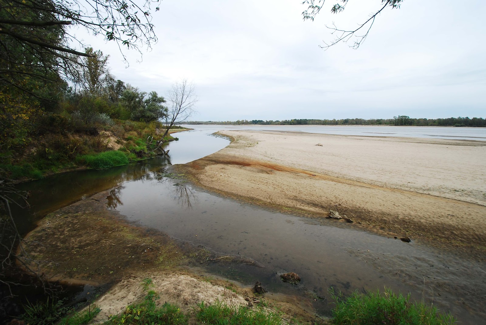
Below: the Jeziorka river flows into the Vistula, from the left. Compare to this view from February. On the Vistula's right bank in the far distance - a similar picture - receding water levels, more exposed sandbanks.


This time last year:
Hip, trendy Ząbkowska

This time three years ago:
Catching that Klimat

This time five years ago:
Road-trip into the Sublime