Showing posts with label river. Show all posts

Tuesday, 26 September 2023

Pilgrimage at day's end

Prompted by Michał Karski's recent comments, quoting Annabel Streets' book 52 Ways to Walk: "So what makes a pilgrimage different from a walk? Firstly, a pilgrimage requires a destination with meaning. In the past this was typically a holy place, but today it might be an ancient tree, the house of an admired painter or architect, somewhere that holds special memories for us, or the site of a rare orchid. Secondly, a pilgrimage requires an intention. This can be as simple as plotting out our day's work, or emptying our mind before bed."

My destination today was to catch a magical scene, one that briefly flashed past my eyes from the Kraków-Warka train exactly a week ago. The sun setting over the Pilica river, a low mist settling over the water meadows to its south. Then, I was unable to catch the shot; the train was going too fast. My intention today? Get the photo I missed, and seek metaphysical experience. 

Today's weather was perfect for said pilgrimage (train from Chynów to Warka Miasto, the connection ideally timed to catch the sun going down).

Below: photo taken from the footway alongside the new rail bridge. I was lucky to catch a lone canoe making its way downstream.


Below: across the Pilica, on the south side, from the railway embankment a view of the river meadow in about a metre of mist, under a painted sky.

Below: from the same spot, change of lens (to super-wide 10-20mm), the rail bridge to the right.


Below: the sun is down, the magic hasn't yet passed... looking towards Hotel Sielanka nad Pilicą, which specialises in equestrian and other outdoor activities.


Below: change of lens again to telephoto... from the north side of the Pilica, the misty meadows look like this...


By the time I reached Warka Miasto, it was too dark to snap. With half an hour in hand before my train back to Chynów, I decided to walk from Warka Miasto to Warka station, just over 20 minutes on foot between the two stations. Total of 12,000 paces for this rail-assisted walk. Train tickets there and back cost 11.44 złotys (just over two quid). For all this gorgeousness. Gratitude!

This time last year:
First steps in cider-making
[Sadly no apples this year!]


This time seven years ago:
On conservatism

This time nine years ago:
Between equinox and equilux

This time 11 years ago:
Heritage or high-rise?

This time 12 years ago:
Shopping notes

This time 13 years ago:
My grandfather

This time 15 years ago:
Surreal twilight, ul.Karczunkowska

This time 16 years ago:
From Warsaw to Seville, via Munich and Madrid

Sunday, 18 July 2021

Warka shows how small-town Poland is on the move

Moni drove over to the działka, and we set off to Warka for lunch, and to see how the railway - and the town - is getting on. In brief - Warka station (1.7km from the town square) is ready - job done, platforms, underground tunnel, waiting room - everything complete. Likewise the new, two-track bridge carrying the Warsaw-Radom railway line over the Pilica river. 

Still to do, the new station, Warka Miasto (a mere 700m from the town square). It's taking shape, not a major job (two platforms, access via stairs to the new viaduct taking ulica Lotników over the railway line). 

Once it opens next spring, Warka will face the same question that many towns with their main railway station far from the centre have - why is that station named for the town located further away than a station much nearer the centre? John Betjeman's poem Great Central Railway springs to mind - "And quite where Rugby Central is/Does only Rugby know"... On the other hand, Warka gets upgraded to one of those Polish towns that has more than one station to its name.

Below: Warka Miasto ('Warka Town') station is located on a curve, just before the bridge over the river Pilica, visible in the distance. Two parallel platforms will straddle the two tracks (before the modernisation, there was only the one line from Warka to Radom). Note the huge pile of apple crates to the right. This is the heart of apple country.


Below: the view from ul. Lotników, looking toward the 'down' platform. What will no doubt delay the opening of the new station will be the installation of level-access lifts from the viaduct down to platform level. At W-wa Jeziorki, this took many months after everything else was ready. Putting in the lifts (for 'up' and 'down' platforms) is by far the most complex part of the remaining works.


Below: the new viaduct is open for road traffic, replacing a gated level crossing that had been here before - a similar situation to that at W-wa Jeziorki. All the ungated crossings on the line to Radom will disappear.


Below: the classic view of the two new bridges, replacing the single-track bridge that had been built here in 1934 (destroyed in WW2 and rebuilt after the war). While the new bridges were under construction, a replacement bus service linked Warka and Radom, meaning journey times from Warsaw to Radom were typically over three hours. Now the work's done, it's an hour and 20 minutes.


The new bridges are of the same design as the old bridge, but with more attention paid to flood prevention. Note the concrete buttressing to the right.


Below: the Pilica is a popular river for canoes, which in Polish are called kayaks. [In UK English, a kayak can be a canoe, but a canoe is typically open from bow to stern.] Today - a sunny Sunday in July - the river was full of small boats heading downstream in the direction of the Pilica's confluence with the Vistula, 17km/10.5 miles to the east.


Below: kayaking down the Pilica has become a big thing. All along the river bank, new hotels and tourist infrastructure has sprung up to cater for the sport. Along the road parallel to the Pilica you can see minibuses with special trailers that can carry ten or so kayaks; they travel empty downstream, and laden with kayaks upstream. Good to see so many people making the most of the weather and the river!


Below: a double-decker Koleje Mazowieckie train on its way from Radom to Warsaw approaches the bridge at Warka.


On the bridge itself - I assume we were not trespassing, as there were no signs prohibiting pedestrians from using the walkway on the western side. In the distance, the tower of the voluntary fire service station in Warka.


Below: I wrote about Warka station in June of last year - since then, the pedestrian tunnel has been completed, the station is ready. The waiting room has a machine serving hot drinks, including rosół (chicken broth), but no small bottles of chilled mineral water for summer. On the west side of the tracks, the tunnel is ready. Like at Chynów station, there are no lifts to platform level from the tunnel, only a set of long and gentle ramps, a more robust solution than lifts which are prone to malfunction. On the other side of the tracks from the station, there's no paved footpath, just muddy puddles. But then access from here to ul. Grójecka is the remit of the town, not of the railway.


We ate at a restaurant called Kociołek, located at the foot of a block of flats some way from the market square. The food was excellent, but what a bill! For two main courses, one prawn starter and two half-litres of 0.0% beer, the bill came to 95 złotys (£17.82). Four years ago, my father, Moni and I lunched in Mogielnica, a small town 32km/20 miles west of Warka, where cold beer, half-litre, two sparkling mineral waters, two soups and three massive main courses came to 52 złotys (£11.17). Inflation is letting rip in Poland, made worse by the effect of the pandemic. Google Maps was still showing us restaurants in Warka that are no longer in business.

This time last year:

This time two years ago:

This time three years ago:
New Nikons on the way!

This time nine years ago:
Work continues on S2, going under the railway lines

This time ten years ago:
Stand Easy! - a short story

This time 13 years ago:
God Save The Queen - I mean it, Ma'am

This time 14 years ago:
Legoland, Dawidy Poduchowne

Wednesday, 4 July 2018

Bristol fashioned

To Bristol, along Isambard Kingdom Brunel’s Great West Railway, calling at Reading, Swindon, Chippenham and Bath, the journey fast and pleasant. A business trip to see a prospective client, four hours’ spare time to have a look around. I’ve not been to Bristol before – certainly not to the city centre, so I made the Most of the chance to see another great British city, historically and economically. As a port, it shares much with Liverpool; built on the transatlantic trade in cotton and slaves. A university city too, the fine buildings located in the centre.

My exploration of Bristol began and finished at Temple Meads station, built in 1843 as (at the time) the western terminal of the GWR. It’s a large station with 15 platforms and an iron and glass roof. The cry of seagulls greeted me as I stepped off the train. Of for my meeting, then a chance to explore the city centre, after which I walked right across town to see the famous Clifton suspension bridge. I must have seen it in early childhood around the time we lived in South Wales. My mother drew a picture of it in pencil on a wooden brick I played with. Along the way, impressive architectural heritage. Unlike Liverpool, there’s no waterfront focal point; the Avon is a much narrower river than the Mersey. And unlike Liverpool, the city is built on steep hills overlooking the river, creating a geography of streets sloping steeply towards the waterfront.

Across the Avon I could see the SS Great Britain, technological marvel of its time, an iron-hulled steamship powered by screws (although the sails were still there). For 1845, a breakthrough. The world's longest passenger ship at the time. Further on, abandoned wooden wharves stand rotting in the shadow of the suspension bridge, a picture of decaying Victorian infrastructure that’s quite unusual in modern Britain.

A massive day’s walking (total over 21,000 paces of which 15,000 were in Bristol). My ticket was purchased via the TrainLine app; this was my very first rail journey in the UK without a piece of paper or card to show to the guard. I’ve been using my phone for plane and train tickets (in Poland) for some time so it’s good to see an alternative to buying online and having to collect the tickets from a machine at the station before departure in the UK.

Below: Temple Meads station. Opened in 1843. That's 175 years ago. Since then, trains have been bringing people here continuously. That's amazing. Gothic Revival, the magnificent roof over the platforms to the right, the main building set at an angle.


Below: the SS Great Britain, along with HMS Victory (Portsmouth), the Cutty Sark and HMS Belfast (London), is one of the famous museum ships that present Britain's glorious maritime past.


Park Street goes up a steep hill from the Cathedral to the Wills Memorial Building, which despite its medieval appearance was opened in 1925 - the last major piece of Gothic  Revival built in Britain. Today it's part of the university . The street itself is testament to the decline of  British retail, with many charity shops and used clothing stores on either side.


The university buildings remind me of Harrow School, but are late-19th century (University College Bristol opened in 1872, the University of Bristol - with royal charter - as late as 1909. Established with money made by selling cigarettes (the Wills family) and chocolate (the Fry family), Bristol is one of the UK's nine 'redbrick' universities, set up at the end of the 19th and beginning of the 20th centuries. Below: the School of Geographical Sciences.


Below: Bristol's very own Wallace Collection - in the 1940s, Bristol was home to the aviation industry (the Blenheim, Beaufighter and Brabazon); today, Bristol is famous for its claymation movies, made by local company, Aardman. Here is Wallace, dressed as a gnome, outside the city's cathedral, established in 1140, though with plenty of Victorian add-ons, including the towers.


Below: I had to wait a few minutes to get this shot of the Foster's Almshouses, there were so many foreign tourists snapping away at it (from France, the US and China). A Victorian building standing on the site of a poorhouse dating back to the 15th century, funded by merchant John Foster.


Below: this waterfront building dates back to 1823; Purifier House was a former gasworks converted into flats. A ground-up rebuild took place (photos on Google Earth Street View show only the left-hand wing standing in 2016).


Below: the Clifton Suspension Bridge, completed in 1864 can rightly be said to be iconic, its image being used so often to promote Bristol and indeed the UK.


South of the bridge, a stretch of waterfront abandoned to the elements; rotting wharves that should have been preserved or demolished, very attractive to the photographer and urban explorer.


The old wharves stretch on and on along Hotwell Road... It's a real surprise to see such dereliction in such a prime location today.


Bristol requires a revisit. A bustling, dynamic city of half a million people, I'd rank it as one of the UK's must-see cities (though Liverpool appeals to me more somehow). Four hours is not enough to explore it. Architecturally, there are many gems to be seen, but the city attracted too many Luftwaffe bombs, losing over 3,000 buildings during WW2. The gaps were filled by much mundane '60s and '70s stuff that creates an overall sense of loss; how the city might have looked with far more of its original architecture intact.

This time last year:
The imminent closure of Marks & Spencer in Warsaw

This time five years ago:
Along mirror'd canyons

This time seven years ago:
Mad about Marmite 

This time eight years ago:
Komorowski wins second round of Presidential elections?

This time nine years ago:
A beautiful summer dusk in Jeziorki

This time ten years ago:
Classic cars, London and Warsaw


Saturday, 30 May 2015

Rural Mazovian toponyms on the way to the Pilica

Riding south out of Warsaw, I pass Nowa Wola, Jaroszowa Wola, Wola Prażmowska, Wola Wągrodzka, Wola Kukalska, Łychowska Wola, Wola Boglewska, Dobra Wola, Wola Palczewska, Biejkowska Wola, Stromiecka Wola or Brzeska Wola. Why so many Wolas? (Wola is pronounced 'VOH-luh')

From Wikipedia: Wola in Polish–Lithuanian Commonwealth, (in Latin libera villa, libertas ) a name given to agricultural villages, appearing from the 13th Century, historically constituting a separate category of settlements in Poland. Settlers were given plots of land and exemption from all rents, fees, and taxes for a number of years. In exchange, feudal landlords, granting these rights, would expect forests to be cleared and cultivation to take place.

Another toponymic suffix that pops up here and there in rural Mazovia is Kolonia (as in Kolonia Brzeźce, Bobrek-Kolonia, Promnia-Kolonia, Częstoniew-Kolonia) - simply 'colony'. People from one village would set up an outlying colony in nearby woods. And then there's Parcela (plural Parcele) as in Michałów-Parcele, Palczew-Parcela, Falęcice-Parcela. Also easy to translate - literally, a parcel of land.

You'll also find plenty of Budy, a word that means huts, shacks, kennels even. Not a complimentary term for your village, should you live in one. (Budy Brankowskie, Budy Michałowskie, Budy Sułkowskie, Budy Opożdżewskie)

Settlements named after Christian names with the suffix 'ów' are extremely common across Poland, every other village in southern Mazowsze seems to have such a name: Michałów, Stefanków, Franciszków, Bronisławów, Edwardów, Henryków, Janów, Józefów.

Other suffixes passed along the way: '-ówka' (as in Kędzierzówka, Jesiówka)  '-izna' or 'yzna' (as in Jakubowizna, or Jazgarzewszczyzna*, down the road from Jazgarzew); '-izna' denotes the gift of land. The suffixes serve to turn an adjective (which ends in an '-ski') into a noun. So 'Dembinski's gift of land' would be 'Dembińszczyzna'; while Michał's gift of land would be 'Michałowizna'.

The suffix denoting a diminutive, '-ek' (as in Czachówek, or in Budziszynek, down the road from Budziszyn) is common. Another very common suffix is '-wice' as in Drwalewice, near Drwalew, Staniszewice or Sułkowice).

Less common in the south of Mazowsze are '-in' suffixes; these are more often to seen in the west of the province, as in Gostynin, Gąbin, Krubin, Dobrzelin, Żychlin, Kornelin.

Other 'easy ones' that translate perfectly from English: Nowy-something (New + name ) and, occasionally, as if to make the point, Stary- something (Old+name); Something Dolny and Something Górny (Lower + name and Upper + name). Duży-something, Mały-something (Large + name and Small + name). However, these are not just prefixes; they can be suffixes too. (Lekarcice Nowe and Lekarcice Stare).

Like in Britain, where toponyms are clues to history (-chester suffixes indicate Roman settlements, while -by indicate Danish ones). I'm sure some Polish local historian has carried out such a survey.

So then - late May, Mazovian country roads, south of Warsaw, to the Pilica (the first major river crossing the main southbound routes from Warsaw). Below: bucolic scene, Brzeźce. In Poland, fields tend not to be enclosed, so to stop cattle from straying, they are chained to the spot. This one, being led from field to dairy for milking, is dragging its chain along the asphalt.


Below: the Pilica at Biejków, looking east. A lovely river, paths on either banks and eminently suitable for boating or canoeing.


Below: the Pilica at Biejków, looking west. The river rises in Silesia, heads north towards Piotrków Trybunalski, then swings east and heads that way until it meets the Vistula north-east of Warka.


Below: the lure of the open road, somewhere north of the Pilica.


* Jazgarzewszczyzna, the second longest single-element placename in Poland - 17 letters long.  Siemieniakowszczyzna, at 20, is the champ.

This time last year:
Carrying the weight on both shoulders

This time two years ago:
Railway history - the big picture

This time four years ago:
A new lick of paint form W-wa Powiśle

This time five years ago:
The ingredients of success

Saturday, 22 September 2012

Ever lower flows the Vistula

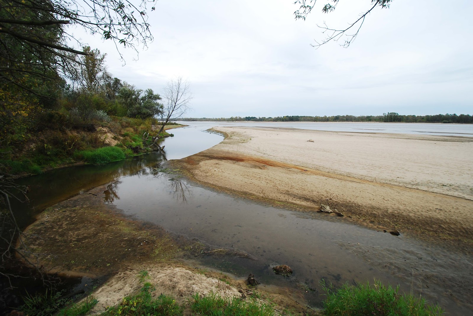
The Vistula is currently at its lowest levels since records began back in the 18th Century. Scatts has picked up the topic at Polandian, referring to the historical artefacts that have surfaced as water levels recede. Today, rather than going into town to snap to our dwindling river, I visited the Vistula downstream at Obory, a favourite spot, and one I've blogged several times before.

Below: Many's the time I've parked my bike here - and always, directly at the bottom of the riverbank was water. Now, it's at least 50m to the water. (Compare to this photo, looking south rather than north, taken in June 2008 from roughly the same spot.)


Below: I clamber down the embankment, and walk over the dry sand to the end of the promontory formed by a sandbank rising out of the river. The last time I was here was when the river froze over earlier this year.


Below: standing at the water's edge. There's a noticeable improvement in water quality when I compare the Vistula from even four years ago. Raw sewage is no longer being pumped into the river in vast quantities. Here, EU money, in the form of structural and cohesion funds, is working its magic as more and more local authorities upstream have built water treatment plants.


Below: the Jeziorka river flows into the Vistula, from the left. Compare to this view from February. On the Vistula's right bank in the far distance - a similar picture - receding water levels, more exposed sandbanks.


This time last year:
Hip, trendy Ząbkowska

This time three years ago:
Catching that Klimat

This time five years ago:
Road-trip into the Sublime