Showing posts with label Warsaw Metro. Show all posts

Sunday, 2 January 2022

Grabów, Krasnowola and Jeziorki Północne

Not that often that I visit the north of my little manor - Jeziorki Północne north of ulica Sporna, up and over the S2 and into Grabów. Once I used to drive the children to school this way every morning. Many years ago. What was driven is now walked. So, join me for a stroll.

Below: the bottom end of ul. Kujawiaka, where it meets ul. Jeziorki. This muddy track, maybe three metres wide, is a proper Warsaw street; the sign informs taxi drivers where Zone 2 begins, the Warsaw equivalent of  "double-time on the metre, guv." What taxi driver would like to venture down here?


Ul. Kujawiaka was once called ul. Poloneza. Since the S2 cut a line across the Jeziorki-Grabów border, the lower part of it (1.5km) south of ul. Krasnowolska, has been renamed, up to and including the viaduct that crosses the S2 and the Metro's rail link to the outside world. From the narrow muddy path, above, to a four-lane road in a few hundred metres. The northern end, north of ul. Krasnowolska, retains the Poloneza name.

Below:
S2 heading east, photo taken from ul. Kujawiaka. Note the railway line to the right of the photo - this is the Metro rail link.


Below: 400m separates a muddy path to a four-lane viaduct - the same road. Ul. Kujawiaka, looking towards its northern end, where it joins ul. Krasnowolska.


Below: Krasnowola bus loop - end of the line, by a decorated wayside chapel. This is where the 239 terminates, a weekdays-only local line linking Grabów with the metro. The bus stop is numbered 51, the '5' prefix suggests a temporary location. When the 239 was inaugurated in January 2018, WTP stated that this would be the case, with the intention of finally locating a permanent bus loop some half a kilometre further west (ul. Tramblanki). With the S2 tunnel now open and the S7 extension nearing completion, perhaps WTP will get round to finalising this route...


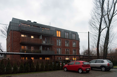
Below: repurposed brick - ul. Poloneza, south of  ul. Krasnowolska. The building (also visible in the photo above) was built during WW2 by the German occupiers to house force labour. In the late 1990s/early years of this century, it was used as a dziupla ('hidey-hole') for car thieves, who'd bring stolen cars here to be dismantled for parts. Since then, it has been converted into trendy apartments!

Below:  the 160-year old Willa Krasnowola - I wrote about this crumbling ruin nearly 14 years ago (June 2008); it's still there - neither demolished, nor repurposed - just standin' over there, decaying.

Below: looking along the unelectrified coal-train line to Okęcie sidings. To the left, the lights of the S79 expressway, set low under the flightpath to Runway 33 of Warsaw Okęcie airport. The  twin-track electrified mainline is to the left of the entirely separate single-track coal-train line.


Below: the Metro rail link, looking towards the lights of Mordor (Służewiec Przemysłowy as was, now one of Warsaw's main office districts).


Below: the Metro rail link looking towards Ursynów and the curved bridge carrying it over the S2. From here, across ul. Puławska and into the Las Kabacki forest, the line runs parallel to the expressway.


Below: ul. Hołubcowa, south of the viaduct. Another one of Warsaw's roads that runs out of asphalt and carries on to its end in the form of a muddy track meandering through fields - a track capable of swallowing cars (even 4x4s) up to their axles in thick goo.


Below: ul. Sztajerki, caught in the crook of two expressways a main railway line and international airport. Otherwise, a quiet backwater of Warsaw, around 7 miles from the city centre. Like so many streets in Zielony Ursynów ('green Ursynów') west of ul. Puławska, from Poleczki in the north to Sarabandy in the south, are named after dances. A 'sztajerek' is a folk-dance related the Ländler, being a dance in 3/4 time once popular in Austria, Bavaria, German Switzerland, and Slovenia.


Left: looking towards the top end of ul. Kujawiaka. In the foreground a small pond - the land here is poorly drained. Although there's a fair amount of traffic turning onto Kujawiaka from ul. Ludwinowska, there's little traffic continuing along Ludwinowska heading for ul. Sztajerka. Note the luminous green orb by the tree in the foreground - an internal reflection within the lens of the streetlight diagonally opposite it in the frame.


Left: ul. Kujawiaka again, this time heading back down south towards ul. Jeziorki. An airliner is on final approach to touchdown at the airport.

Miserable but warm weather (10C) and cloudy; not the stuff of flashbacks, blue skies, sparkling snow and a crisp frost. A different atmosphere altogether. Maybe flashbacks for another time, and another place.


This time four years ago:
1929-1939; 2008-2018?

This time six years ago:
Track works between W-wa Okęcie and W-wa Dawidy

This time eight years ago:
The benefits of extending the human lifespan 

This time 11 years ago:
New Year's stocktaking

This time last 12 years ago:
A walk in the wild winter woods

This time 13 years ago:
Now that's what I call winter vol. 12

This time 14 years ago:
When the day starts getting longer


Wednesday, 29 December 2021

S2 opens, unblocking east-west transit through Warsaw

I finally got round to it today - a very long (19,000 paces!) stroll from home to the western portal of the S2 tunnel, which was opened on Monday 20 December. 

Story so far - the A2 motorway/S2 expressway, which form the Polish part of European Route E30 (Cork to Omsk), got as far as Warsaw in 2012 (in time for that year's European football championships). Since then, transcontinental traffic heading east would get as far as this junction with ulica Puławska (below), and would then solidify into one huge constipated jam made up of local, regional, national and international traffic on Dolina Służewiecka. Now, over 11 years after the A2/S2 reached Warsaw, the route finally gets to cut through to the other side, via a 2.3km-long tunnel diving under the southern suburb of Ursynów. [The sign above the slip-road states that traffic over 16 tonnes is prohibited from using the S2 between 7-10am and 4-8pm. Much transit traffic will continue to use the DK50, but anyone who can will rather use the S2 - it's  27km shorter.]

For about two and half kilometres, the S2 runs parallel to a single-track railway line, the umbilical cord linking Warsaw's Metro system with the outside world. Rarely used these days (new Metro rolling stock now gets delivered by road!), the rails themselves are lightly coated with rust, suggesting the infrequent passage of a maintenance draisine. Below: looking west towards ul. Puławska, the slip-road joins the S2 to the right. The acoustic screens are effective - the roar of Puławska way behind me is louder than the traffic on the other side of the screen.


Below: looking towards the western portal of the tunnel. It dives down beneath the Metro, building the tunnel with minimal disruption to the Metro service was quite a feat of engineering! The sign says that average speed is being measured; cameras automatically capture each vehicle as it drives in and drives out of the tunnel and work out its average speed. You have been warned. 

Below: going underground. Above the tunnel, there has been much structural change to the fabric, the look-and-feel of Ursynów. I found it difficult to get my bearings along ul. Płaskowickiej, a street which I once knew intimately from morning runs to my children's primary school. 

I chose to return through the Las Kabacki forest. The Metro's rail link at this point, at twilight, takes on a very specific, eerie air. It is as if I have entered Tarkovsky's зона from Stalker by night...

Some subtle Photoshoppery going on here... That glow in the distance is from the Metro maintenance depot, but it feels like could be an atomic weapons manufacturing facility in the Urals...

On the way home I take the long way around to take a stroll over the ice on the pond on ul Pozytywki before it melts. The sign prohibits angling and littering, but there's plenty of evidence of ice-skating going on. Absolutely rock-solid ice - and you can see the high level of water in the pond this year. I like the horizon on this photo, the wires, lights and foggy sky.

Below: looking at ul. Pozytywki from the middle of the pond; a strong 1950s USA vibe. "Approaching the country club in midwinter."


I'd like to share two particularly atmospheric digital works from my brother; the one below is based on my recent photo of the new roundabout by the S7 extension viaduct - Cold fronts, Atlantic depressions and winter storms.


Below: the National Air Traffic Control radar installation, Claxby, Lincolnshire.


This time last year:
The first year of Covid-19

This time two years ago:
Last night in Ealing, twenty-teens
[A strangely prophetic post, suitably dream-like in quality]

This time three years ago:
The Day the World Didn't End
[The world's gone more shit-shaped than I dared predict]

This time six years ago:
Hybrid driving - the verdict

This time eight years ago:
Pitshanger Lane in the sun

This time 12 years ago:
Miserable, grey, wet London

This time 12 years ago:
Parrots in Ealing

This time 13 years ago:
Heathrow to Okęcie

Tuesday, 11 February 2020

Dark, wet, gloomy February - no winter

Grim blows from the west the remains of Storm Ciara (renamed 'Sabina' in Poland for some reason); wave after wave of dark clouds propelled by howling winds, bearing great amounts of rain. I dodged a shower and got to W-wa Jeziorki without getting wet... would I be so lucky during my stroll to the office?

Below: the area around Rondo Daszyńskiego is climbing skywards. Not good weather for the construction sector...


Outside W-wa Śródmieście station, the rain is chucking it down. So I nip through Patelnia and into the Metro Centrum station, along the shopping galery overlooking the platforms (below). This way I can get to ulica Złota in the dry, and then shelter under arcades of Ściana wschodnia (the old Wars, Sawa and Junior buildings) to get to the south-east entrance of Metro Świętokrzyska. Down the stairs and through the passages and I emerge outside the doors to my office - nearly dry.


Below: not so lucky on the way home; it wasn't raining when I passed the Palace of Culture, but the malignant threatening tower merited a snap.


Onward, not far to the entrance to W-wa Śródmieście station (on this side of Aleje Jerozolimskie from the Polonia Palace Hotel). Within a few seconds of taking this photo, the heavens opened and a tremendous downpour sent people sprinting for the nearest shelter.


My train was delayed for some reason, crawling between stations then stopping for ages; no explanation given (unlike those helpful Tube announcements in London). I arrive at W-wa Jeziorki, miss the 209 bus from the (still after all these years temporary) bus loop 'near' the station, and proceed home on foot in the teeth of the ongoing downpour. Usual story - no pavements, sides of ulica Karczunkowska turned into huge, muddy puddles. So I'm walking along the wet asphalt into the oncoming traffic, which mercifully is driving a bit more slowly and cautiously than usual. Once again, my message for local authorities is get some pavement laid here before someone gets killed again.


This time last year:
The filth and the fury
[Since then the paths to the station have been paved, but still no pavement alongside Karczunkowska]

This time four years ago:
Defining the human experience

This time six years ago:
The City of Warsaw wants you to complain

This time seven years ago:
Czachówek's wild woods in winter

This time eight years ago:
Vistula freezes over downstream of Warsaw 

This time nine years ago:
Twilight of the Ikars

This time ten year ago:
Polish TV adverts for parapharmaceuticals

This time 11 years ago:
Jeziorki wetlands in winter

This time 12 years ago:
A week into Lent


Sunday, 20 January 2019

Las Kabacki - forest in winter, with rails

Walking to the Las Kabacki forest from home, I passed upon this lovely 1950s America scene, against a clear blue sky, below. In the distance, the PWPW security-printing press and Karczunkowska Office Park.


Below: the forest itself is icebound; the snow has largely melted but the paths remain icy - where the snow was compacted then frozen again. Safer to walk along the edge than slip and slide down the middle.


Today was an opportunity to photograph the far end of the Metro rail-link (pictures from its source at W-wa Okęcie, over Puławska and into the western edge of the forest here). Below: looking west from ul. Moczydłowska.


Below: looking east towards the Metro depot. To the left, new housing development, surrounded with spike-topped fencing, not only to keep strangers out of the estate, but to keep neighbours out of one another's gardens. Paranoia!


Below: looking back west, the snow-covered section of track in the above photo is visible in the distance, giving an idea of how big the new estate is.


Below: reverse view from the above shot, looking at the (heavily graffiti'd) gates and wall around the Metro depot. Inside, hidden from view, the sidings and shed and above-ground infrastructure of Warsaw's Metro technical base.


Below: two white houses on the corner of ul. Leśna and ul. Moczydłowska, on the edge of Las Kabacki forest.


A grand day, weather-wise, first sunshine in weeks, sorely needed!


This time two years ago:

This time five years ago:
Rain on a freezing day (-7C)

This time six years ago:
Jeziorki in the snow

This time eight years ago:
Winter's slight return

This time nine years ago:
Unacceptable

This time ten years ago:
Pieniny in winter

This time 11 years ago:
Wetlands in a wet winter

Saturday, 27 October 2018

Metro rail-link bridge over Puławska: jams ahead

News is that ulica Puławska – that inescapable, unavoidable road into central Warsaw from the south – choked up solid as it is, will get worse. The bridge taking the single track linking Warsaw's Metro to the outside rail network is due for a major remont. Built in 1984 (11 years before the Metro opened!) the line links the Metro depot in Kabaty with the railway sidings at W-wa Okęcie. The bridge, spanning eight lanes of traffic (three plus three and two slip lanes) is in poor condition.

Below: from left to right – the acoustic screen of the S2 expressway; the S2 as it reaches its double-hairpin junction (where the traffic lights are); in the distance the work is under way to extend the S2 under the blocks of Ursynów, and the bridge, spanning Puławska.


Below: the bridge was built with walkways on either side. These have been closed off to pedestrians (indeed in the photo above, you can see a chap vaulting over the barrier). While there are steps at the other end of the bridge, there is no access on this side. The railway line itself is extremely rarely used; these days major movements of Metro rolling-stock are done by road (sadly). The only traffic I've seen on this line has been maintenance draisines, maintaining the track for the sake of keeping it maintained. Question – will the bridge continue to provide pedestrian access after the remont?


Further east, where the Metro rail link approaches the main Warsaw-Radom line, and the parallel coal train line. Below: in the foreground, the Metro line curves north, while in the background a bit of a rarity – a former East German loco developed from the Soviet-built M62 (in Poland known as the ST44). Post-unification, the Germans called this class of diesel freight locos BR232; this one is in the livery of CargoUnit, a rolling-stock rental firm, and is heading a rake of empty coal wagons back to Okęcie sidings from Siekierki power station.


Below: the Metro rail link, having crossed Puławska and skirted around the south-western outskirts of Ursynów, cuts through the edge of the Las Kabacki forest before reaching the Metro depot. This is a popular spot for recreation.


Below: a mountain for bikes – Bike Park Kazoora, one of Ursynów's two artificial hills made from builders' spoil from when the blokowiska were being built.


Below: the S2, meanwhile, heads east towards the Vistula (work on the new bridge is continuing on both banks); to get there, the S2 must dive under Ursynów – and indeed, under the Metro. Cut and cover by ul. Płaskowickiej, looking east.


Back by bus to W-wa Okęcie, I walk back along the Metro rail-link from where it starts. The buffers (below) are the symbolic end of the line; the link itself to the rest of the railway network runs to the right of the photo.


Just before I reach the S2 by Węzeł Warszawa Południe, I see a rare sight – a four-engined plane coming into land – an Airbus A340-300. Owned by Maltese airline Hi Fly (registration 9H-FOX), it is currently on lease to LOT Polish Airlines, and has been recently flying the Warsaw-Toronto route. No livery – just plain white. LOT is experiencing difficulty at present, with a pilots' strike and maintenance issues. Wet-leasing planes from other airlines is a stop-gap remedy for the moment.


Below: a LOT Boeing 787 Dreamliner crosses the S79 on final approach to Okęcie.


Back at W-wa Dawidy, I catch a rake of aviation fuel cisterns heading up the coal-train line towards the airport. No longer are the cisterns taken all the way into the fuel depot by rail – a new oil terminal has been built alongside the main railway line (south of the Poleczki viaduct); the fuel is pumped via an underground pipeline to the airport a kilometre away. The pipeline does away with a three-kilometre-long railway spur from the main line to the airport's fuel terminal.


Hauled by a NEWAG-refurbished SM42 (now known as a 6Dg) in Lotos livery, the train has just passed three signs warning the driver that the train will be passing points that lead onto an electrified section.


Below: a full load of biomass for co-firing with coal at Siekierki, on its way to Okęcie sidings, hauled by an ET22 loco through W-wa Dawidy station.


It is quarter past five and still light; by tomorrow the clocks go back and the sun sets an hour earlier – 16:14. The hammer of darkness is about to come down once more.

This time last year:
We are what we read, what we watch, what we listen to

This time five years ago:
Extraordinarily warm autumn

This time six years ago:
On behalf of the work-shy community

This time seven years ago:
Classic truck cavalcade

This time eight years ago
Suburban back-roads clogged with commuters

This time nine years ago:
Autumn gold, Łazienkowski Park

This time ten years ago:
Quintessential autumnal Jeziorki

This time 11 years ago:
Google Earth updates its map of Jeziorki

Wednesday, 1 February 2017

How to annoy the passengers

As I wrote six months ago, the area around Metro Wilanowska, a major public-transport junction served by the Metro, trams and buses, is being redeveloped. The main pedestrian thoroughfare has been closed for the duration, which might be another year to 18 months. In the meanwhile, passengers changing from bus to Metro, or Metro to bus, must take a detour.

The planners dreaming up the temporary footpath have made a big mistake. This is where the 709, the main public transport conduit between Piaseczno and Warsaw, terminates - a bus that at peak times runs once every five minutes, each bus carrying over 170 passengers. Nearly 2,000 people per hour are disgorged from this one, single bus line. And this is one of 15 bus routes that finish or start their journeys from Metro Wilanowska.

Below: this, the newest Google Earth image of the area (from September 2016) shows how public transport planners believe passengers will walk from the Metro station to the head of the 709 bus stop (red line). The short yellow line shows how passengers actually do walk.


Rather than yield to the convenience of passengers, they are forced to make an 110-metre long detour, snaking south-west then back east to get to where the 709s start from. The planners ensure compliance by erecting metal barriers along the proscribed path.

Will the people listen? No. The demolish the barriers, knocking them down. The authorities put them back up again. The passengers knock them down again. The authorities should take note - lay some temporary paving slabs making the shortest distance between Metro and bus stop. But no - they keep putting the barriers back up again. And then the passenger knock them down again.

Below: this evening, the barriers are down. And there's plenty of people going this way, rather than the long way round. If the bus is about to depart shortly (and the 715, for example also starting from here, runs once an hour), you don't want to be making a 110m detour.


Below: overnight, the barriers were put up again. They get in the way. People climb over them, knock them down. This is just stupid.


Surely the authorities can learn from this. Simply connect the buses with the metro with some temporary paving slabs, lift them up when the building work's completed, and lay the grass back down again... Otherwise, passengers will get the impression that they are ignored and despised by the very people that should be aiding their mobility.

Same thing at W-wa Okęcie station. I've written about this before. Ten months after the completion of the new foot bridge, it is still blocked off pending final approval by the building inspector. 'No entry! Construction Site' says a sign on a wire mesh fence. Which has been summarily demolished by passengers, angered at the alternative - walking a longer, more dangerous route, over live railway tracks.

Below: the barrier ignored. I admire my compatriots for their refusal to bow to the laziness and stupidity of officialdom.


Planners, builders, administrators - THINK!

This time last year:
Zloty symbol - your suggestions

This time two years ago:
The future of Warsaw's public transport

This time three years ago:

This time five years ago:
(on the superiority of Polish schools to British ones)

This time seven years ago:

This time eight years ago:

This time nine years ago: